

Top 7 Oregon Waterfalls for Your Bucket List
Oregon is waterfall country — where rivers carve deep canyons, volcanic cliffs create dramatic drops, and mossy forests cradle cascades that look straight out of a fairytale. After years of exploring Oregon’s wild places, Ruby and I have discovered some of the most breathtaking waterfalls in the Pacific Northwest.
In this post, we’re sharing 7 epic waterfalls you absolutely must visit — plus a couple of honorable mentions — to help you plan your next Oregon road trip or adventure.
Below, we have included our YouTube video and embedded a map to make your journey easier.

7. Tumalo Falls
📍 Cascade Lakes Highway / Deschutes National Forest
📏 Height: 97 feet
🚶♀️ Access: Short walk to overlook; extended hikes available
Location & Access
Just 12–14 miles west of Bend, Tumalo Falls is situated in the Deschutes National Forest along Tumalo Creek. The day-use area is managed by the Forest Service.
Parking is extremely limited (vehicle length limit: 27 feet) and fills fast. Visitors should pay close attention to “NO PARKING” signage — roadsides may look tempting but must stay clear for emergency access.
Waterfall & Surroundings
Tumalo Falls drops about 97 feet in a clean plunge over a resistant lava flow overhang. The canyon was scorched in the 1979 Bridge Creek Fire, and although regrowth has reclaimed much of the forest, faint scars still trace portions of the slope.
Hiking & Experience
The Tumalo Creek Trail (out-and-back ~6.4 mi, ~557 ft gain) gives you a more immersive route, connecting to upper cascades and forest scenery.
For a shorter option, you can take the North Fork Trail / loop to Double Falls (~89 ft) and other small drops upstream.
A lesser-known spur trail (unsigned in spots) leads down to the base of Tumalo Falls — expect steep, slick conditions and some scrambling.
History & Name
The name “Tumalo” likely originates from Klamath words such as tumallowa (“icy water”), temolo (“wild plum”), or temola (“ground fog”). Nearby lies the ruins of the Tumalo Dam, an early 20th-century irrigation project that attempted to trap water but failed to realize its full potential.
Photography Tips
Early morning light often glows along the canyon walls — arrive before 7 a.m. to beat the crowds. Use a neutral density (ND) filter to soften the flow into silky ribbons. Try viewpoints from above the falls or farther downstream to frame more of the creek’s context. In summer, the base trail is steep and wet — water-resistant boots and caution are essential.
Nearby Attractions
Double Falls and other upstream cascades along Tumalo Creek
Sparks Lake is a beautiful place to camp and explore with epic views of South Sister and Broken Top on the trail near the boat launch.
Bend itself — breweries, alpine lakes, and desert transitions await after your hike.
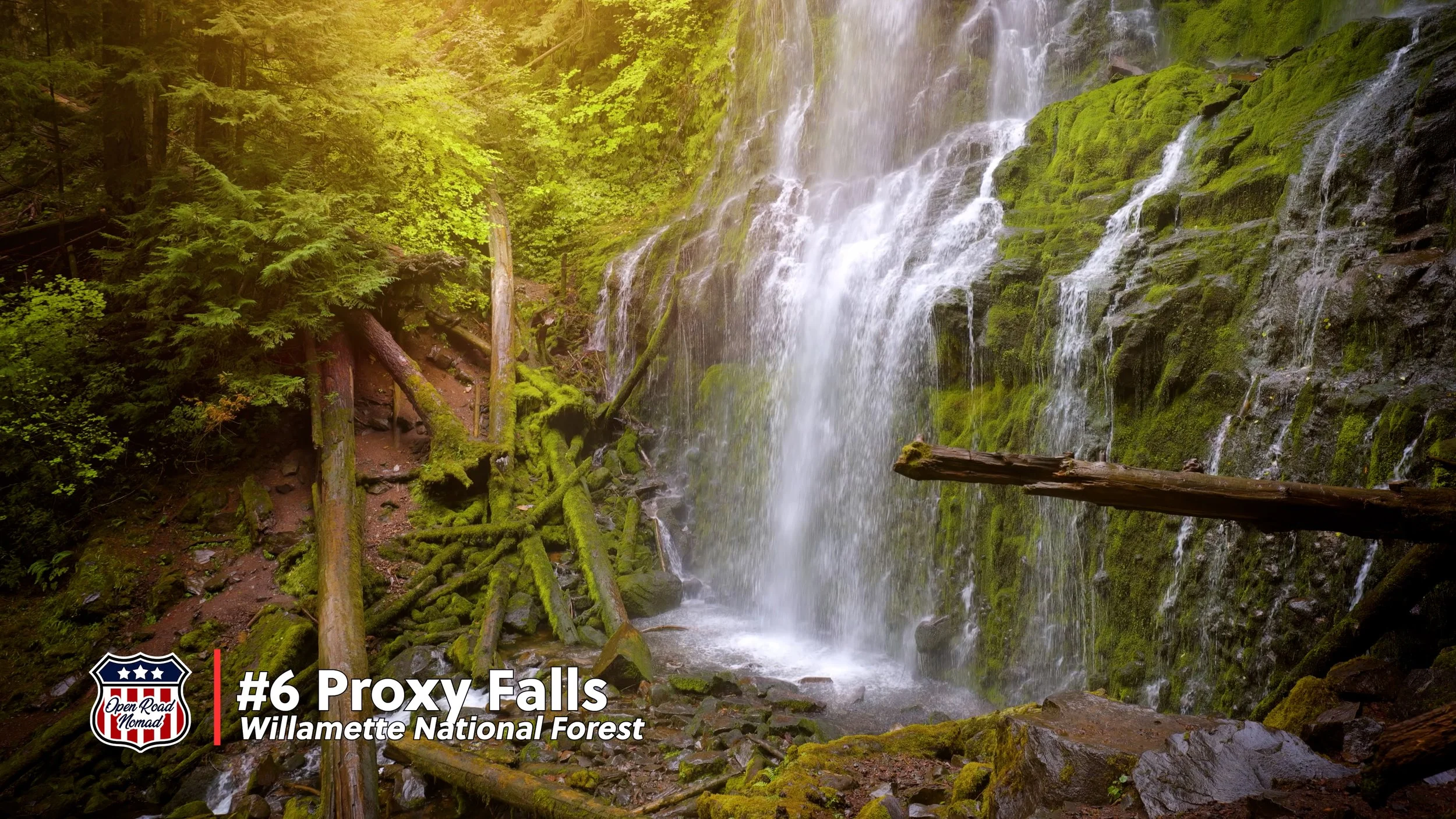
6. Proxy Falls
📍 McKenzie Pass Scenic Byway / Willamette National Forest
📏 Height: 226 feet
🚶♀️ Access: 1.5-mile loop trail
Location & Access
Proxy Falls lies off McKenzie Highway (OR 242) in the Cascade Mountains, accessed via Trail #3532 in the Willamette National Forest. Highway 242 is seasonal — typically closed mid-winter through late spring because of snow.
Waterfall & Unusual Features
Proxy’s main drop is 226 feet — one of Oregon’s higher plunge waterfalls. What makes Proxy truly magical: at the falls’ base, the water seems to disappear. In reality, it sinks into porous lava and flows underground. There are actually two falls in the loop: Lower Proxy Falls and Upper Proxy Falls, connected by the trail.
Trail & Visitor Notes
The loop is roughly 1.5 miles and is considered a moderate hike - mostly easy but with some slick sections, especially at viewpoints. Parking is limited (15–20 cars). The trailhead has a vault toilet and picnic area and dogs are allowed on leash.
Interesting Observations
The trail passes across an old lava flow now colonized by vine maple — especially beautiful in fall color. Take note that the latter part of the loop (especially if walked clockwise) lacks shade — bring water and sun protection. Some approach the lower falls via more adventurous routes off-trail — these are not always safe or sanctioned.
Photography Tips
Overcast days soften contrast and enhance mossy greens — ideal for capturing detail in the shaded amphitheater. Use a wide-angle lens to include the lava-rock foreground and forest canopy. For long exposure, pick smaller aperture (f/11–16) to get the falls silky while keeping rim details sharp.
Nearby Attractions
The Dee Wright Observatory atop the lava flows on McKenzie Pass (great for sunset / crater views).
Additional trails along the McKenzie corridor, hot springs (Belknap) and scenic lava fields.
As fall approaches, the surrounding forest transitions into a canvas of red and gold.
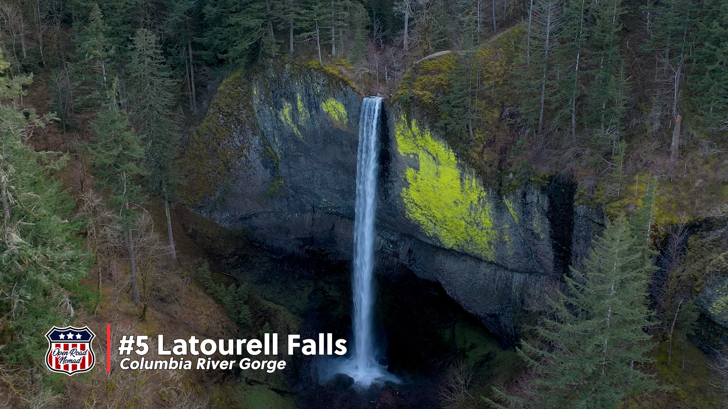
5. Latourell Falls
📍 Historic Columbia River Highway, east of Portland
📏 Height: 249 feet
🚶♀️ Access: Roadside viewpoint and short trail
Location & Access
Tucked just off the Historic Columbia River Highway near Corbett, Latourell Falls is one of the most accessible and photogenic falls in the Gorge. There’s a small parking area and an easy trail down to the base (part of a ~2.4 mile loop hike that includes Upper Latourell Falls).
Waterfall & Setting
Latourell drops 249 feet off a sheer basalt cliff. The basalt columns behind the falls add vertical drama and context of the volcanic history of the Gorge.
Historic Note
Latourell Falls is one of the earliest developed falls along the old Columbia River Highway — travelers have marveled at it since early 20th century. The landowner, Joseph Latourell (postmaster & homesteader), lent the name to the site.
Trail & Experience
The loop is mild; many visitors only go to the lower falls since the view is stunning from there. When doing the loop, go counterclockwise is often recommended so the harder uphill section is first. Expect crowds, especially midday and on weekends, since it’s close to Portland and very accessible.
Photography Tips
Use the cliff wall to your left as a natural frame for a dramatic composition. A slow exposure (1–2 seconds) softens the flow and pairs well with the textured basalt behind. Arrive at mid-morning for side light on the water (eastward exposure).
Nearby Attractions
Bridal Veil Falls and Wahkeena Falls lie along the same scenic corridor and pair nicely in a half-day Gorge drive.
Vista House at Crown Point for sweeping panoramic views above the falls corridor.
Hidden cascades like Lower Latourell if you follow spur trails north of the loop.

4. Toketee Falls
📍 Umpqua River Scenic Byway
📏 Height: 113 feet (two tiers)
🚶♀️ Access: 0.8-mile round trip hike
Location & Access
Toketee Falls is located along Highway 138 on the Umpqua River Scenic Byway, between Roseburg and Diamond Lake. The trail to the viewing platform is roughly a half mile round-trip, modest elevation gain, and well maintained. A large portion includes numerous stairs and meanders along a wooden penstock from the dam up river.
Waterfall & Geology
Toketee is a double-drop waterfall, with water cascading over basalt ledges into a cold plunge pool below. The basalt framing is part of Oregon’s volcanic backbone and gives the falls a striking amphitheater set.
Visitor Experience
Because the upstream river is regulated (via dams), Toketee maintains reliable flow year-round — rare among Oregon’s falls. The platform viewpoint gives an excellent full view. Some adventurous hikers scramble off-trail for alternative angles (but beware of slippery terrain).
Photography Tips
A moderate shutter (⅓–½ sec) captures the motion without safety risk of starburst effect. Include some reflecting pool foreground for layered depth. Use polarizer filters to cut glare on wet basalt surfaces.
Nearby Attractions
Watson Falls (290+ ft) is a short detour eastward — one of Oregon’s tallest single drop falls.
The North Umpqua Scenic Byway is lined with old-growth forest, swimming holes, and river access.
The Umpqua Hot Springs and nearby trails make this a perfect multi-stop region.
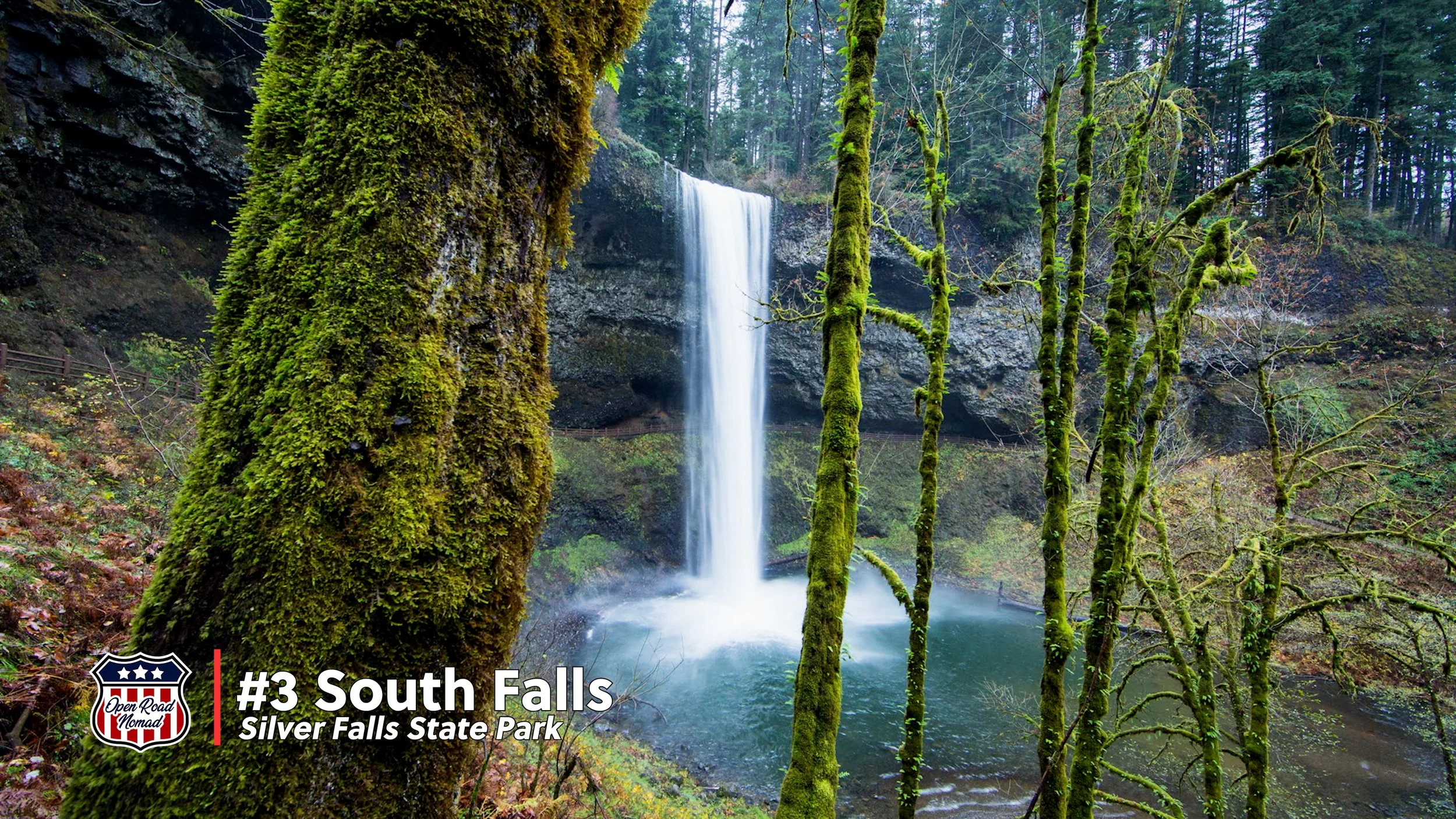
3. South Falls
📍 Silver Falls State Park, east of Salem
📏 Height: 177 feet
🚶♀️ Access: Part of the 9-mile “Trail of Ten Falls” loop
Location & Access
Nestled east of Salem, near Silverton, Silver Falls State Park is Oregon’s largest state park by waterfalls. South Falls is part of the famed Trail of Ten Falls, ~9 miles loop.
Waterfall & Unique Feature
South Falls plunges ~177 feet into a fern-lined granite canyon. What sets it apart: the trail actually allows you to walk behind the curtain of water, offering a rare immersive perspective.
Visitor Experience
The Trail of Ten Falls showcases nine other named waterfalls. Many visitors spend the full day exploring. The “behind-the-falls” path is well maintained, but damp and slippery — wear sturdy footwear and expect spray. In summer, crowds can be heavy; morning visits get you ahead of peak traffic. The state park features a large parking area, lodge with cafe and bookstore, and an adjacent campground.
Photography Tips
Use a backlighting setup for the walk-behind segment to catch the water’s translucence against silhouettes. At the base, frame silhouettes of the rock arch to add scale. In fall, golden light filters through the canopy, adding warmth to green mossy walls.
Nearby Attractions
Other falls like Middle North Falls, Canyon Falls and North Falls all within the loop.
The park lodge (built 1940s) houses a café, visitor center, and shelter from rain.
Camping within the park lets you stay overnight and catch sunrise/sunset scenes without the crowds.
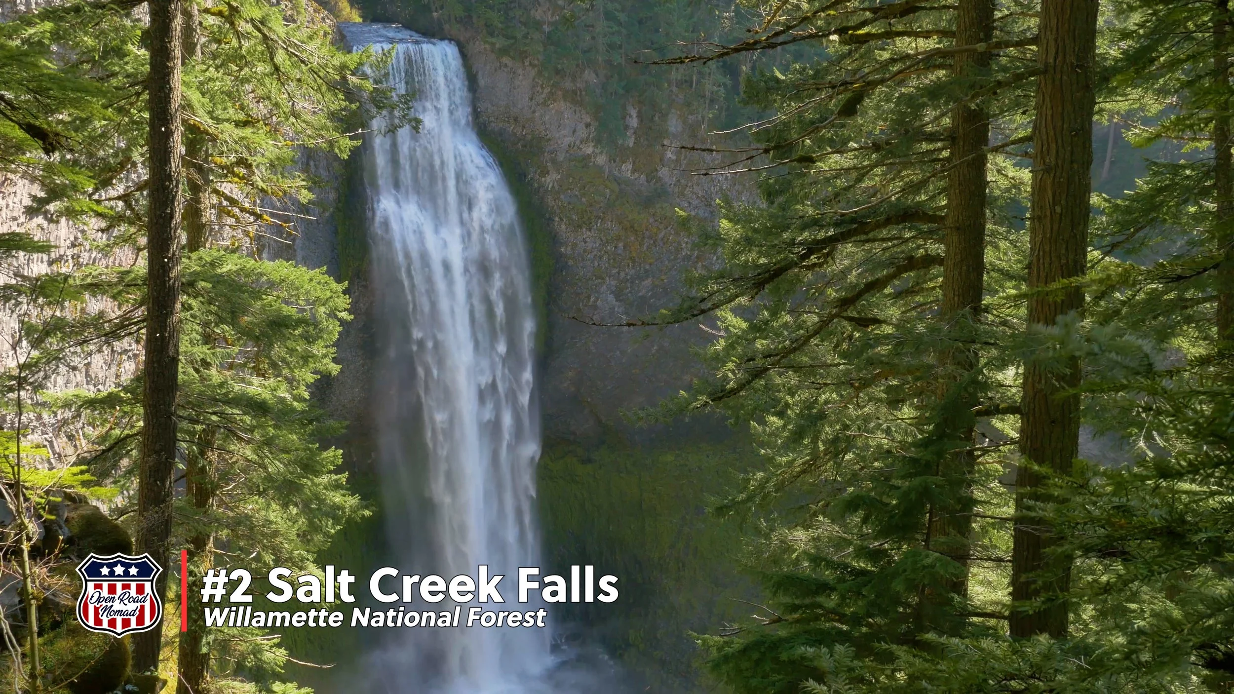
2. Salt Creek Falls
📍 Off Highway 58, between Oakridge and Crescent Lake. Willamette National Forest
📏 Height: 286 feet
🚶♀️ Access: ADA-accessible viewing platform; steep trail to base
Location & Access
Salt Creek Falls lies off Highway 58 between Oakridge and Crescent Lake in the Willamette National Forest. The falls are 286 feet tall, making them Oregon’s second-highest waterfall.
Visitor Experience & Facilities
A paved, ADA-accessible viewing platform offers a stunning viewpoint. A steeper trail descends to the canyon floor for a more immersive perspective (not for the faint of heart). In spring or early summer, snowmelt gives the falls tremendous power — you may feel the mist from the overlook. In winter, freeze / ice features are dramatic, but approach with caution. Facilities are not plowed or maintained in the winter months.
Photography Tips
Use a shorter exposure (1/4 to 1/2 sec) to balance flow with texture. Afternoon light is best as it shines up the canyon lighintg the basalt cliff face. Take a walk down the trail to the base of the falls. There are neumerous places along the jouney to stop and frame up a beautiful shot with the forest in the foreground. In winter, vantage points covered with ice create surreal geometric composition opportunities.
Nearby Attractions
Diamond Creek Falls, Clear Lake, or Crescent Lake make ideal tie-ins.
Combine with a drive over Willamette Pass or stops along the McKenzie or Cascade corridors.


Honorable Mentions
Whitehorse Falls
📍 Highway 138, near Toketee Falls
📏 Height: 14 feet
🚶♀️ Access: Steps from the parking area
Small but stunning, Whitehorse Falls is my personal favorite in the state. It is atranquil little gem tucked just off Highway 138 in the Umpqua National Forest — only minutes from Toketee Falls. At just 14 feet tall, its scale is modest, but its setting is pure magic: a broad sheet of water spilling over mossy rock into a crystal-clear pool framed by old-growth forest.
This is an ideal stop for a picnic or a moment of quiet between larger adventures. The easy accessibility makes it perfect for travelers of all ages or those short on time. In autumn, the surrounding maples light up with color, while in winter, the falls often form delicate icicles and a mirror-like pool below.
Pro Tip: Visit early morning or late afternoon for soft light and still reflections. Bring a thermos of coffee — this spot is perfect for soaking in the peace and sound of rushing water.
Horsetail Falls
📍 Historic Columbia River Highway, near Multnomah Falls
📏 Height: 176 feet
🚶♀️ Access: Roadside viewpoint + optional trail to Ponytail Falls
Right off the Historic Columbia River Highway, Horsetail Falls is one of Oregon’s most photogenic “drive-up” waterfalls. It plunges 176 feet in a perfect free fall that resembles — you guessed it — a horse’s tail. You can literally pull off the road, step out of your car, and be greeted by mist and the thunder of water within seconds.
For a quick hike, follow the Horsetail Falls Trail up a short climb (about 0.4 miles) to Ponytail Falls, a smaller cascade that you can walk behind — a lesser-known thrill in the Gorge.
Fun Fact: Horsetail Falls is one of the few waterfalls visible year-round without any hiking at all, making it a favorite stop for travelers on tight schedules or rainy days when you don’t want to stray far from the car.
Photography Tip: On sunny afternoons, watch for rainbows in the mist. If you have time, capture long-exposure shots from across the pool where reflections ripple against the basalt backdrop.
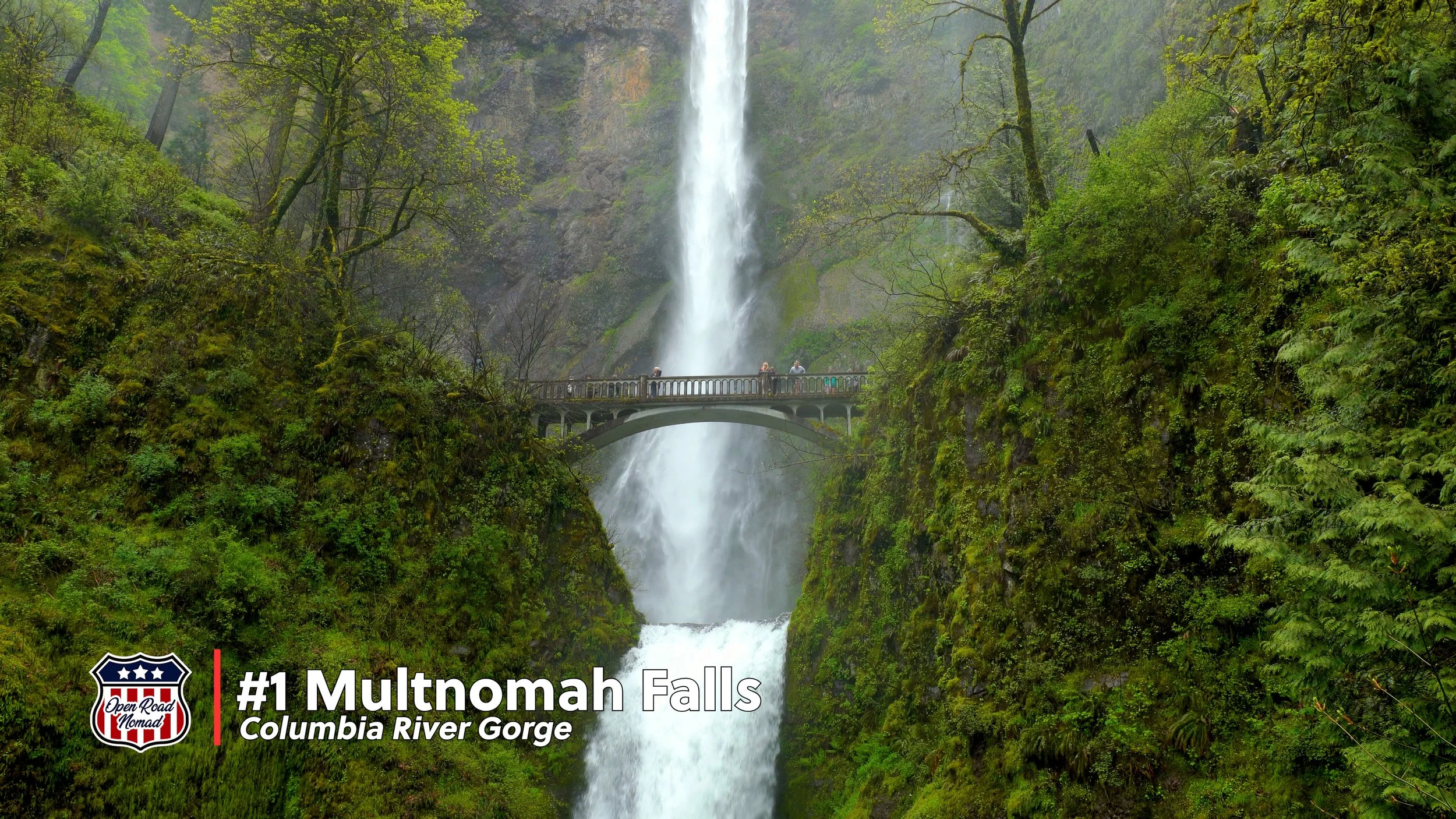
1. Multnomah Falls, Columbia River Gorge
📍 Exit 31 off I-84, near Bridal Veil
📏 Height: 620 feet (two-tiered)
🚶♀️ Access: Paved trail to Benson Bridge; optional upper trail
Location & Access
Easily located with a tip east on Interstate-84 at exit 31, Multnomah Falls is perhaps the most iconic waterfall in Oregon and one of the Pacific Northwest’s most visited natural sites. The area can also be accessed by taking the historic Columbia River Highway out of Corbett.
Waterfall & History
At 620 feet (two-drop cascade), Multnomah is the tallest in Oregon and the PNW. The Benson Bridge, spanning the falls at ~105 feet above the base, was constructed in 1914 and has become an iconic photo spot. To manage high visitation, the site now enforces timed-entry permits and limited parking during peak season.
Trail & Experience
The paved path to the Benson Bridge is short and accessible. A longer trail leads up to the Multnomah-Wahkeena Loop, offering upstream views and waterfalls like Wahkeena Falls. In fall, the falls are surrounded by beautiul autumn colors. In winter, parts of the falls freeze, creating ice-clad walls and dramatic winter photo settings.
Photography Tips
Use a vertical frame to emphasize the height and structure of the two tiers. Use early morning fog for atmospheric shots. At low light or in shade, a tripod + long exposure (1–3 sec) helps smooth the water while keeping the details crisp. Use additional elements such as pathways, rails, and lighting to accent and frame the photograph.
🌿 Nearby Attractions
Wahkeena Falls, Wahclella Falls, Oneonta Gorge are all nearby in the Gorge corridor.
Vista House at Crown Point offers sweeping views above the Gorge.
Columbia River Gorge Historic Highway with viewpoints, wildflowers, and classic Gorge scenery.
Plan Your Oregon Waterfall Adventure
Each of these seven waterfalls offers a different facet of Oregon’s natural charm — whether it’s plunging heights, mossy amphitheaters, hidden forest magic, or accessible power. Combine multiple stops per day, chase light through the seasons, and bring patience — waterfall magic often reveals itself to those willing to wait.
Ruby’s Final Thoughts
“From Tumalo to Multnomah, I’ve chased these falls with Brian and paws full of wonder. Which one will you chase next? Drop your favorite below — and don’t forget to watch the video so you can see every cascade in motion!”
Travel Guides
Explore in-depth resources designed to help you plan unforgettable adventures. Featuring tips, tricks, can’t-miss stops, and insider insights, these guides make it easier to discover hidden gems, plan efficient routes, and get the most out of every road trip.
Buckle up and let’s discover paradise together!